SCIPHYR Wind Analysis Method - BREVe Comparison
Date: 29/10/2024
Versions: 2024.07+
Program: MasterKey Wind Analysis
Introduction
From the 2024 version onwards, MasterSeries now uses the SCI wind analysis program called Sciphyr whereas previously the BREVe wind analysis had been used.
The data in Sciphyr has been updated and refined to suit changes in the topography, etc from when BREVe was first introduced a couple of decades ago.
It is assumed the user is reasonably familiar with the EuroCode wind analysis methods – EN 1991-1-4 and the related UK National Annex. There are other documents which back up the EuroCode, for example - BRE DIGEST 436 which are also taken into account.
Initially the features of Sciphyr and their background are explained. Subsequently the features and workings of Sciphyr and BREVe are compared and contrasted.
Sciphyr features and background:-
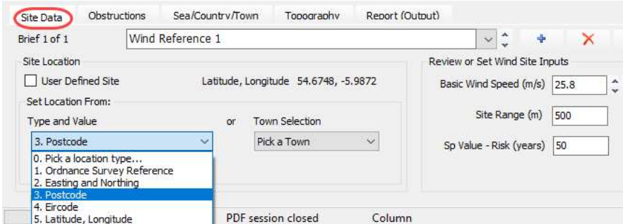
Site Data Input site location options – you can input the site location as an Ordnance Survey Reference, a UK Easting and Northing, and IRL Easting and Northing, a UK postcode, an Irish eircode or as Latitude and Longitude. A useful website is the Grid Reference Finder app which will give the various location input options for any particular site.
You can also select or refine a site from the satellite/terrain maps at the top of the screen. Simply double click on the exact location to choose the site. Then click on the ‘Recalculate’ button between the 2 maps to update the calculation of the wind pressures.
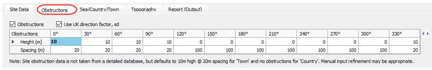
Obstructions
Height and spacing of obstructions are per each 30 degree angle – note:- site obstruction data is not taken from a detailed database (the site data doesn’t contain individual data for every building, but for a general area), it defaults to 10m high buildings at 20m spacing for ‘Town’ and no obstructions for ‘Country’. Therefore a manual input refinement may be appropriate where required.
The UK national annex simplifies the terrain categories to either Sea, Country or Town (NA.2.11), which both Breve and SCIPHRY use for the Cr roughness correction factor. Breve does have the more refined categories given in the euro norm code (table 4.1), which are used for refined obstruction data, e.g. category 3 produces Height = 2.5m and Spacing of 4m obstruction in Breve (rough country or low rise town/hamlet) . SCIPHRY does not have the refined categories of table 4.1, but only the simplified sea, country, town categories of the UK national Annex, hence the default obstruction are different from BREve.
Any obstruction data entered for roughness sector classified as 'Country' are ignored, whereas Breve was happy to implement obstruction for country sectors. A sector would need to be changed to ‘Town’ (by setting 'In Town (km)' distance and also entering the word 'Town' in the Terrain) before the obstruction data is used in SCIPHYR.
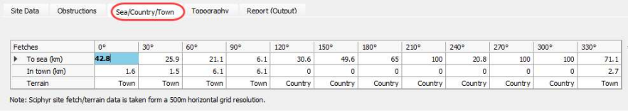
Sea/Town/Country
Fetches are at 30 degree angles. Note that the Sciphyr site fetch/terrain data is taken from a 500m horizontal grid resolution, where as BREVe used 1kM.
The SCIPHYR data is based on up-to-date online maps and there certainly seems to be more built-up areas than Breve would indicate as it is based on older maps, maybe 20 years old.
In any case it's worthwhile pointing out that both Breve and SCIPHRY operate to a 1km resolution for terrain categories, so there can certainly be anomalies in edge conditions. The facility to edit and refine the site data returned is still in place for 2024, as this is an essential feature for fine tuning the data.
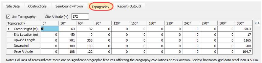
Topography
Orography per 30 degree angle
Note – Sciphyr is dealing with a 500m grid data resolution for the topography. BREVe was using 200m and therefore appears better in terms of picking up sharp topographical features, eg, escarpments and cliff edges, etc. This may be why Sciphyr shows columns of zeros in the topography table indicating no significant orographical features in certain directions. Hence BREVe may have been more accurate in this area giving different wind pressures to Sciphyr.
The 500m range is a radius – cross sections across the topography are taken in various directions to ascertain the ground cross sections and what is upwind and downwind and what angles the ground rises and falls by. Only certain conditions will trigger a set of data. Some slopes will be too shallow to register and so zeros are input in Sciphyr whereas BREVe would have included the data even though it wasn’t relevant.
When we migrate a Breve site to SCIPHYR we do a full recalculate based on the new SCIPHYR data, hence the obstruction data is recalculated.
When entering manual site/sector topography data, the upwind slope and downwind slope ratio are required inputs and are not inferred from the slop lengths and crest height.
Note – Whilst noting the differences between Breve and SCIPHYR in orography, during testing for any detailed examination of differences in sites it was the generally the conclusion that SCIPHYR results where able to be justified (even given its less refined 500m resolution). SCIPHYR has no short term plans to adopt a smaller resolution for topography. Besides the resolution difference, the method used to idealize the topography as shown in the ground shapes in the code is open to interpretation.
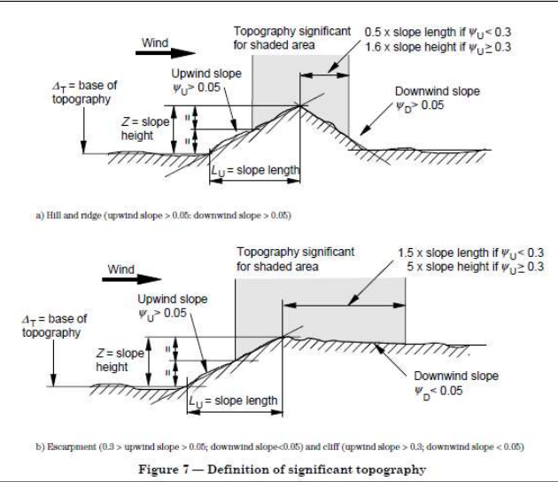
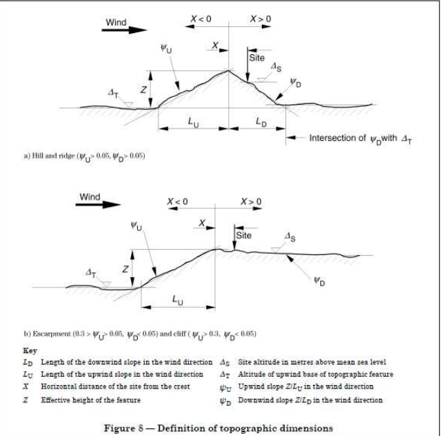
Diagrams showing definitions of significant topography and topographical dimensions:-
Treatment of Significant Bodies of Inland Water in accordance with BRE DIGEST 436
Both SCIPHYR and BREVe observe the guidance with regard to significant bodies of water in BRE Digest 436, however there are cases where the implementation has shown to be different. For example reference Northern Ireland site with postcode BT36 4PP - Mallusk. Lough Neagh is seen as at a distance to sea in the west for SCIPHYR, whereas it is the Atlantic coast for Breve that is taken as the distance to water . Reading BRE DIGEST 436 rules on this (distance wind travel across the water is greater than the distance from the shoreline to site) it’s a close call, and likely relates to how the variable distance across water is determined for the sector. SCIPHYR is more conservative in this instance but neither BREVe or SCIPHYR can be said to be incorrect.
Design Methods
Breve can use either the Designer’s Guide Design Method. SCIPHYR does include this method.